Melbourne is often regarded for its cultural heritage, art, and sports history. But are there any lovely walks to enjoy with the family? Yes! There are plenty of picturesque walks and magnificent scenery to marvel at in Melbourne – you just need to know where to look.
Today, we have eight pram friendly walks in Melbourne for you to choose from, including Foreshore Trail, Albert Park, and the Royal Botanic Gardens.
Key Points
- The Studley Park Boathouse is a beautiful pram friendly walk if you want to stop for lunch, too
- The Royal Botanic Gardens are fantastic to spend the entire day at
- Collingwood Children’s Farm is a not-for-profit perfect for young and older kids
Content in this article:
- Jells Park
- Hobsons Bay Coastal Trail
- Capital City Trail
- Studley Park Boathouse
- Royal Botanic Gardens
- Collingwood Children’s Farm
- Albert Park
Jells Park
Location: Jells Rd, Wheelers Hill VIC 3150, Australia
Getting there: Get directions to Jells Park
Jells Park is a beautiful walk for families thanks to the relatively easy 2.5 km looping trail. This park is a popular place for birding, walking, and running, and it’s a common place for people to visit daily. So, you’ll probably meet lots of people there to enjoy the scenery with!
The park’s trail loops around Jells Lake, with walkways and viewpoints for you to spot waterbirds and fish. Visitors will often see the likes of native ducks, cormorants, herons, coots, and even pelicans here! Birds often migrate from China and Japan to Jells Park in summer, so this is the perfect time to take a family walk!
How Long Does It Take To Walk Around Jells Park?
The main trail around Jells Park is around 2.5 km, which should take you no longer than 45 minutes to complete. However, there is plenty to stop off at and check along the way, so why not bring a picnic and make a whole day of it?
What Facilities Does Jells Park Have?
Toilets: There is a toilet block at Jells Park, equipped with changing facilities and wheelchair access.
Kids playground: There are multiple kids’ playgrounds at Jells Park, perfect for your little one to burn off some energy before leaving.
Parking: There are several large car parking areas around Jells Park, each with accessible spaces for wheelchair users and prams.
Public transport access: There are several bus stops around Jells Park, with the closest being Petronella Avenue on Wheelers Hill. Glen Waverly train station is also nearby.
Wheelchair accessibility: Jells Park is completely accessible for wheelchair users.
Hobsons Bay Coastal Trail
Location: The Hobsons Bay Coastal Trail follows the coastline between Westgate Bridge and Skeleton Creek.
Getting there: Get directions to Hobsons Bay Coastal Trail
Walking map download: View here
Whether you are passionate about walking trails or want to enjoy a pram walk, the Hobsons Bay Coastal Trail is a great choice. The coastline walk takes you from the Westgate Bridge to Skeleton Creek. This rounds out at around 23 km, so you might not get the entire way in one trip! But the beautiful views will definitely have you wanting to come back and see more.
The path is mostly shaded, making it perfect for younger babies who can’t be out in the sun for too long. The water is gorgeous, and there are plenty of grasslands to stop and have a picnic on.
How Long Does It Take To Walk Around Hobsons Bay Coastal Trail?
The entire coastal trail is 23 km, which will take around five or six hours to walk – or even longer with a pram! So, you probably won’t get to see the entire trail in one go with your little one. However, you can always come back and pick up where you left off on another day!
What Facilities Does Hobsons Bay Coastal Trail Have?
Toilets: There are toilet blocks along the long trail and food places that may have bathrooms available for customers.
Kids playground: There are no kids’ playgrounds along the Hobsons Bay Coastal Trail.
Parking: You can find both metred and free street parking along the Hobsons Bay Coastal Trail. The most popular places to park are within Williamstown and Altona.
Public transport access: There are plenty of buses that stop near the Hobsons Bay Coastal Trail.
Wheelchair accessibility: The coastal trail is made from concrete, making it a wonderful place for wheelchair users.
Capital City Trail
Location: Capital City Trail, Docklands VIC 3008, Australia
Getting there: Get directions to Capital City Trail
Walking map download: View here
Whether staying in the heart of the city or just taking a day trip, the Capital City Trail is an excellent way to explore all the sights the city centre has to offer. The circular trail surrounds Melbourne’s city centre and some of the eastern and northern suburbs. This trail is around 30 km, but we love that you can leave the park whenever you want to explore different parts of the city!
Some people call the Capital City Trail a mashup of lots of other walks in Melbourne, as it uses parts of the Yarra Trail, Moonee Ponds Creek Trail, and the Merri Creek Trail! Families who love exploring new walks will love the Capital City Trail, as you’ll enjoy many smaller trails connected together!
How Long Does It Take To Walk Around Capital City Trail?
Capital City Trail is 30 km, as it is made up of multiple other trails. Overall, this would take around six hours, at least! However, you don’t need to stay on the trail the entire time. You can walk as long as you like before hopping off the trail to explore another area of Melbourne’s fantastic city.
What Facilities Does Capital City Trail Have?
Toilets: There are many cafes dotted around the Capital City Trail which will have toilets accessible for customers.
Kids playground: There are many kids’ playgrounds to visit around the Capital City trail, with Collingwood Children’s Farm being one of them.
Parking: Thanks to the sheer size of this trail, there is parking dotted all along it. Simply find where you want to join the Capital City Trail to find where the best parking is.
Public transport access: There is plenty of public transport for visitors of the Capital City Trial. Buses and trains stop frequently all around the trail.
Wheelchair accessibility: The wide paths of the Capital City Trail are wheelchair accessible.
Studley Park Boathouse
Location: 1 Boathouse Rd, Kew VIC 3101, Australia
Getting there: Get directions to Studley Park Boathouse
Walking map download: View here
The Studley Park Boathouse is the oldest public boathouse on the Yarra River, serving over 160 years! It’s one of the main tourist attractions in Melbourne, and there’s a beautiful walking path around it! Enjoy everything the Yarra River has to offer on the wide path, with lots of shady spots to sit and take a break.
When we visited the Studley Park Boathouse, one of our favourite things to do was sit on a bench and watch the world go by while our baby napped in his pram. It was one of the most peaceful places we’ve ever visited, and the sweet wildlife was a plus!
How Long Does It Take To Walk Around Studley Park Boathouse?
The walk around Studley Park Boathouse is around 1.36 km, which should take around 20 to 30 minutes to complete. It’s a short but sweet walk along the Yarra River, and you can end the walk with a delicious meal at the Boathouse. Yum!
What Facilities Does Studley Park Boathouse Have?
Toilets: There are toilets located in the Studley Park Boathouse.
Kids playground: There are play areas within the Boathouse.
Parking: Parking is available off Boathouse Road, which can be found next to the Studley Park Boathouse and picnic area. There is additional parking up on Yarra Boulevard, and this is a short walk down the hill.
Public transport access: You can get to the Studley Park Boathouse by bus.
Wheelchair accessibility: The lower path to the boathouse is wheelchair accessible, as well as the walking trail.
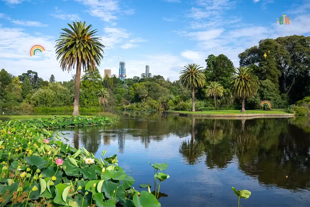
Royal Botanic Gardens
Location: Melbourne VIC 3004, Australia
Getting there: Get directions to Royal Botanic Gardens
Walking map download: View here
It’s almost unheard of to go to Australia and not visit one of their many botanical gardens. The Royal Botanic Gardens is one of the most impressive, with two sites – one in Melbourne and the other in Cranbourne. Founded in 1846, the Royal Botanic Gardens are on the southern side of the Yarra River – why not grab a bite to eat at the Studley Park Boathouse before enjoying everything the gardens have to offer?
The Melbourne Royal Botanic Gardens expands over 38 hectares with more than 8,500 plant species! There are activities for the entire family, such as garden explorers and forest therapy, or you could take one of the gorgeous walks as a family. We highly recommend visiting the Royal Botanic Gardens if you find yourself near the Yarra River during your trip.
How Long Does It Take To Walk Around Royal Botanic Gardens?
The Royal Botanic Gardens offers a longer walk at 4.61 km, which will take you around 1 hour 15 to walk. However, there is so much to see around the gardens that you might find time slipping away from you!
What Facilities Does Royal Botanic Gardens Have?
Toilets: There are designated toilet blocks dotted around the Royal Botanic Gardens for your convenience.
Kids playground: The Royal Botanic Gardens houses a Children’s Garden, where there is plenty of room for your little one to jump, run, and play. However, this might not be open at certain times of the year.
Parking: There is street metred parking near the entrance of the Royal Botanic Gardens.
Public transport access: There are plenty of trams and buses to get you to and from the Royal Botanic Gardens. Flinders Street has many stops that you can use to get where you need to go.
Wheelchair accessibility: The wide walkways are ideal for wheelchair users at the Royal Botanic Gardens.
Collingwood Children’s Farm
Location: 18 St Heliers St, Abbotsford VIC 3067, Australia
Getting there: Get directions to Collingwood Children’s Farm
Any parent visiting Melbourne needs to know about Collingwood – a not-for-profit farm found along the Yarra River. There is plenty to do here for adults and children, and you can walk around the park at a leisurely pace. From the guinea pig snuggle corner to the goat feeding experience, your kids will love every part of your walk through the Children’s Farm.
Collingwood Children’s Farm is the perfect way to combine your holiday with a learning experience for your child. And you can stop by the gift shop on the way out to get them a memento!
How Long Does It Take To Walk Around Collingwood Children’s Farm?
Thanks to the many activities here for young and older children, you can spend as many hours at Collingwood Children’s Farm as you like. The walk around the farm shouldn’t take longer than an hour, but be prepared to stop and say hello to plenty of animals!
What Facilities Does Collingwood Children’s Farm Have?
Toilets: There are public toilets at the entrance of Collingwood Children’s Farm, found just after you enter the park.
Kids playground: There are several kids’ play areas around the farm.
Parking: There is a designated parking area for visitors,
Public transport access: You can get to Collingwood Children’s Farm by train, bus, and bike. The Johnston/Clarke Street bus stop is the closest to St Heliers Street.
Wheelchair accessibility: There are plenty of accessible features around Collingwood Children’s Farm to make it suitable for wheelchair users.
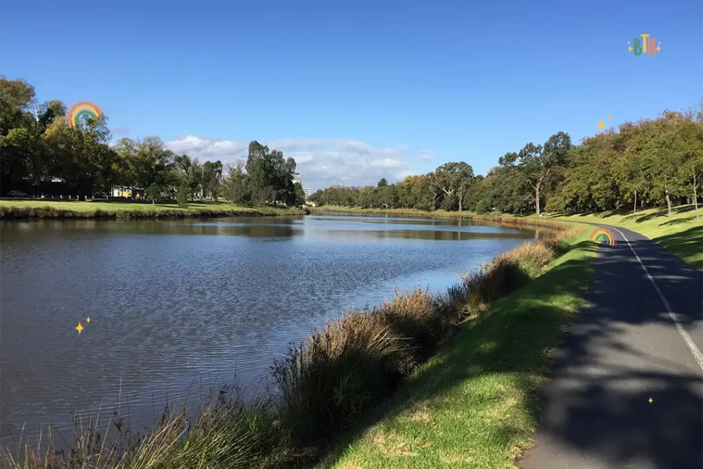
Albert Park
Location: Albert Park, Victoria, 3206
Getting there: Get directions to Albert Park
Walking map download: View here
Albert Park is a beautiful option for parents who want to take their babies on a leisurely walk along Hobsons Bay. Attractions and tourist spots are fun, but sometimes you want somewhere to relax and unwind as a family. Albert Park is the ideal location for just that, with 4 km of grasslands, playgrounds, and shaded walkways. We recommend Albert Park for any parents who want to enjoy a relaxing walk while their baby sleeps in their pram.
How Long Does It Take To Walk Around Albert Park?
The walk around Albert Park’s lake is around 6.33 km, which will take around two hours to walk. However, there are plenty of other diversions to take if you don’t want to stick to just the lake. There are lots of smaller paths that are still suitable for prams, so keep an eye out while you’re walking.
What Facilities Does Albert Park Have?
Toilets: There are two separate toilet blocks in Albert Park, which are free for guests to use.
Kids playground: You can find lots of children’s play areas dotted around throughout Albert Park.
Parking: There is both on-street and off-street parking at Albert Park, all requiring the same tariffs.
Public transport access: The nearest tram stop to Albert Park is 134 Carter Street/Mills Street, with a three-minute walk from the stop to the park. There are also multiple bus stops.
Wheelchair accessibility: Albert Park is wheelchair accessible.
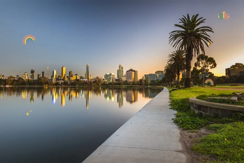
Final Thoughts On Pram Friendly Walks Melbourne
Sometimes, a walk in the fresh air is just what you need for some family bonding time. Luckily for visitors of Melbourne, this city isn’t short of excellent walks to embark on with little ones in their prams! Many walks here are surrounding water, so you’ll be guaranteed gorgeous views and fantastic picture opportunities. Now we’ve given you some inspiration for your next trip, which walks are you most excited about?